CoreCommand® · Counter-UAS command and control software Fuse. Confirm. Respond.
A multi-sensor C2 platform that correlates and fuses tracks from integrated sensors into a single operational picture, for faster assessment, coordinated response and interoperability across agencies and systems.
Every sensor has its own console. Operators have one set of eyes.
Radar, cameras, RF detectors and ADS-B each report the same target in their own way, on their own screen. Operators end up reconciling alerts instead of assessing the threat.
CoreCommand sits above the sensors. It ingests their detections, correlates them into one track per target, puts a camera on that track, and gives the operator one place to confirm and respond. Personnel, vehicles, UAS, aircraft and vessels can all be tracked, depending on the sensors integrated in the deployment.
Customers don't need another sensor. They need the sensors they own to work as one system.
Above the sensors. Ahead of the response.
CoreCommand takes detections from the sensors on site, turns them into one confirmed picture, and sends that picture to the people and systems that act on it.
Radar · EO/IR cameras · RF/DF and Remote ID · ADS-B and AIS · LiDAR and acoustic
Fuse one track per target · Confirm with slew-to-cue and CoreAI · Respond with rules, alerts and actions
Operators · video management · ATAK / WinTAK · open REST API · alerts and external systems
People, vehicles, drones, aircraft and vessels. One map.
CoreCommand tracks whatever your sensors can see: personnel, vehicles, UAS, aircraft and vessels.
Each object becomes one track, with its source sensors, position history, speed, altitude and heading, whether one sensor reports it or five. Integrated radios and field comms add your own teams to the map as Blue Force tracks.
2D and 3D maps, one track per target.
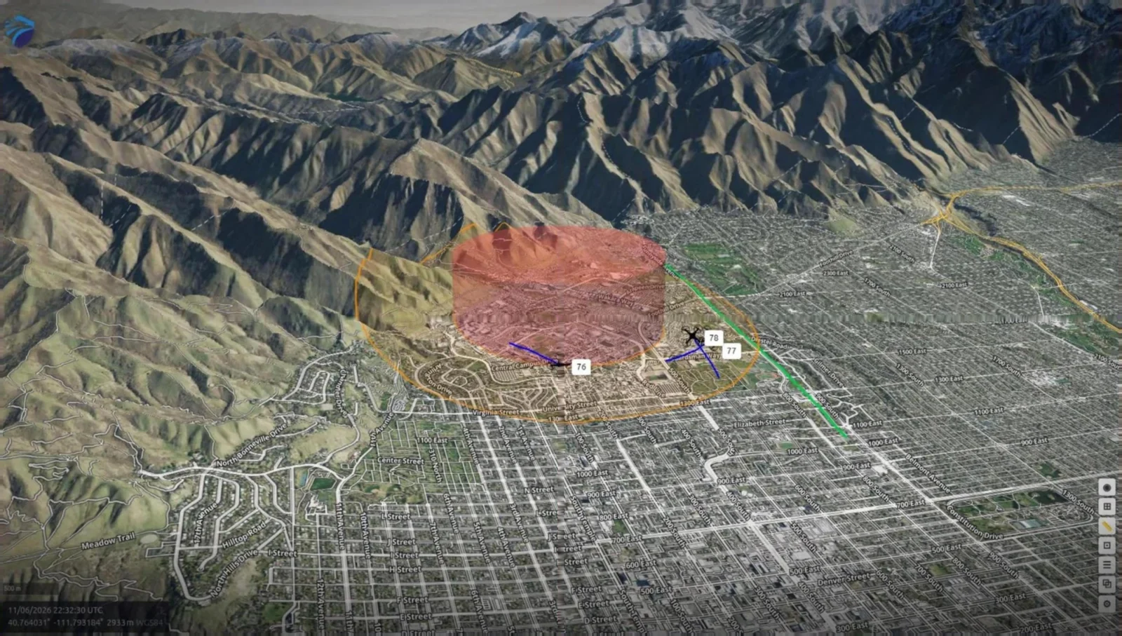
- Each target appears once, however many sensors see it
- 2D satellite and 3D terrain views of the same picture
- Alarm regions and geofences drawn on the map
- Cameras slew to the selected track
The full interface is shown in a live demonstration.
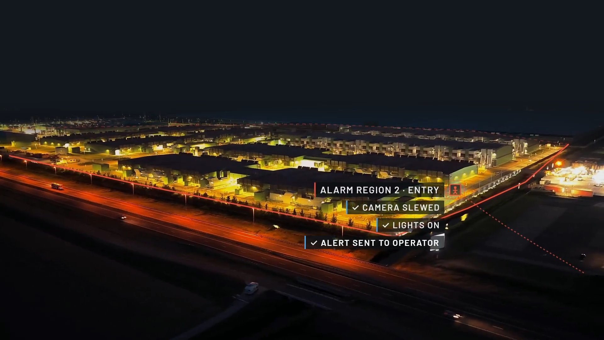
A breach is an action, not just an alert.
Draw alarm regions and geofences on the map and decide what each one does. When a confirmed track crosses a line, CoreCommand can slew cameras, trigger strobes, sirens or other external systems, notify operators, and push the track to ATAK/WinTAK and your VMS.
- Configured per region. Each alarm region carries its own rules and operator actions.
- Confirmed before it escalates. Operators verify on camera before a response goes out.
- Recorded. Event footage and the track history are kept for review.
Operational C2 built for interoperability.
Correlate across sensors
Real-time track correlation merges detections from every integrated sensor into one operating picture.
Verify the target
Camera slew-to-cue and operator tools put eyes on the track and confirm what it is.
Trigger and share
Alarm regions, geofences and operator actions drive the response and push it to connected systems.
What operators get.
Open architecture
Streamlines sensor integration and long-term support.
Real-time sensor fusion
Track correlation across radar, EO/IR, RF and other inputs.
Slew-to-cue
Camera integration that points imaging at the active track.
2D and 3D maps
Visualize tracks, sensors and coverage on both views.
Alarm regions and geofences
Configurable regions, geofences and operator actions.
Linux and web UI
Installed Linux application with a browser-based interface.
One system. Three jobs.
Act on confirmed tracks
2D and 3D maps, confirmed tracks, slew-to-cue, alerts with actions attached.
Run the shift and the record
Shared picture across shifts and agencies, event history, reporting and data export.
Configure and connect
Sensor onboarding, alarm-region setup, role-based access control, audit log, REST API.
From one fence line to a deployable fleet.
- Fixed site
- On premises, on a server or VM, for a facility, base or plant.
- At the edge
- On deployable or vehicle-mounted systems such as Falcon Mobile, running where the sensors are.
- Multi-site
- Several sites run as one operation and viewed from one operations center.
- Blue Force and field teams
- Radio and comms systems integrated into CoreCommand carry communication and location data, so in-field operators appear on the same map as the threats.
- Shared picture
- Tracks and alerts pushed to ATAK/WinTAK, VMS and partner systems through the REST API.

Sensors, interfaces and security.
Supported sensors and data sources
- EO/IR imaging systems (commercial and military camera drivers)
- Ground-based radar (2D / 3D / 4D)
- LiDAR
- RF/DF and Remote ID
- ADS-B and AIS
- Acoustic sensors
- Generic inputs over standard network and messaging protocols
Interfaces and integrations
- Open REST API for tracks, actions and third-party applications
- Tactical display: ATAK / WinTAK
- Reporting and data export for interoperability
Video management systems
- Genetec RSA
- Milestone XProtect
- Avigilon
- RTSP and TCP actions
Deployment
- Linux installed application with a web-based interface
- On the customer’s premises: dedicated server or virtual machine
- At the edge: fixed sites and deployable or vehicle-mounted systems
Security
- NIST SP 800-53 Rev. 5 compliant
- Encryption in transit and at rest
- Role-based access control and MFA
- Full audit log
Works with the systems already on site.
CoreCommand® ingests and controls equipment from these manufacturers alongside generic inputs over standard messaging protocols.


















Trademarks and logos belong to their respective owners. Listing reflects technical integration with TKG systems.
Running at real sites.
Multi-sensor command and control for a government research site
CoreCommand delivered on premises as the fusion and display layer for a government research site.
Read the case studyDrone detection at three airports
CoreCommand and 3D radar at a regional airport, and evaluations at two other commercial airports.
Read the case studyAirspace awareness over a dam and reservoir
Layered Osprey SR/MR radar with edge AI video confirmation, specified into a new dam security system.
Read the case studyA rapid-deploy drone detection trailer for an integration partner
360° radar on a standard trailer mast and edge servers in the base, within a trailer’s battery and solar budget.
Read the case studyWhere CoreCommand runs.
Installation protection
Fused ground and air picture for bases and facilities.
Counter-UAS operations
RF, radar and EO/IR correlated into confirmed UAS tracks.
Expeditionary force protection
Runs on deployable systems at temporary sites.
Joint and multi-agency operations
Shared tracks through TAK and the open API.
Critical infrastructure
Perimeter and airspace awareness for utilities and industrial sites.
Correctional facilities
Perimeter and airspace monitoring around secure facilities.
Maritime and port security
Surface and air tracks with AIS and ADS-B context.
Oil, gas and mining
Remote-site perimeter and airspace awareness.
What program managers ask.
Does CoreCommand replace our VMS?
No. It integrates with Genetec RSA, Milestone XProtect and Avigilon, so video stays in the VMS operators already use.
Which sensors does it support?
Any source that outputs structured data. Radar, EO/IR, RF/DF, Remote ID, ADS-B, AIS, LiDAR and acoustic sensors are common; TKG confirms each one during design.
Does it need the cloud?
No. CoreCommand runs on premises or at the edge.
How is access controlled?
Role-based access control, multi-factor authentication, encryption in transit and at rest, and an audit log.
Can our team build integrations?
Yes. The REST API and developer documentation are available under NDA.
Can it run on a deployable system?
Yes, on fixed sites and on deployable or vehicle-mounted systems.
Bring a sensor into CoreCommand.
CoreCommand is built for open integration: new sensors and external systems connect through the REST API and standard protocols. Integration documentation and the API reference are shared with partners and customers under NDA.
See CoreCommand with your sensors in it.
Request a demo, or talk to an engineer about integrating a sensor or system into CoreCommand.