
Free planning tools (editable, no sign-up)
- Drone Incident Response Playbook, sample template (Word): roles, alert levels, step-by-step response, evidence checklist, incident report, after-action review and a vendor evaluation checklist.
- Range and Warning Time Planner (Excel): work out how much warning your detection range gives you, and score your site's readiness.
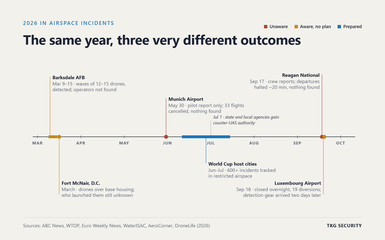
In March 2026, waves of 12 to 15 drones flew over the flight line at Barksdale Air Force Base for nearly a week, about four hours a day. The base detected them, but no one has said publicly who flew them. In May, pilots at Munich Airport reported a single drone, runways closed, and 33 flights were cancelled. Police searched for an hour and found nothing.
Two sites, two very different capabilities, and the same uncomfortable result: a drone set the agenda.
After years of working with airports, utilities, correctional facilities and government sites, we see three kinds of airspace owners. The difference between them is not budget or size. It is what they know, and how early they know it.
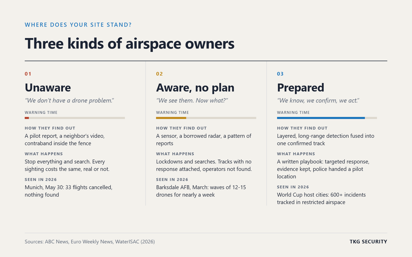
1. The unaware: "We don't have a drone problem"
Most sites with no detection say they have no drone problem. What they mean is that they have no data.
Without sensors, a site learns about drones the hard way: a pilot calls it in, a neighbor posts a video, or contraband turns up inside a fence. That is how the Munich closure began on May 30: flight crews reported a drone shortly after 9 a.m. Runways closed, 33 flights were cancelled and 114 were delayed. The search ended an hour later with nothing found.
On September 17, two crews reported a drone near Runway 19 at Reagan National. Departures stopped for about 20 minutes. Staff searched and found nothing, and the FAA has not said what the object was.
An eyewitness report is not a track. It has no position, altitude or heading, and it cannot be confirmed or dismissed. So the safe answer is to stop everything. Unaware sites pay for every sighting, real or not.
2. The aware: "We see them. Now what?"
The second group knows drones are overhead. They may have an RF sensor, a radar on loan, or a pattern of reports they can no longer ignore. What they lack is a plan for what happens next.
Barksdale is the clearest example. The base detected multiple waves of 12 to 15 drones over the flight line, ordered a shelter-in-place on March 9, and watched the flights continue for nearly a week. The drones used long-range control links and resisted jamming. Investigators said their routes may have been chosen to keep the operators from being located.
Over Fort McNair in Washington, D.C., several drones appeared in a single night. The Army said it was aware of the sightings and saw no credible threat. Who launched them is still an open question.
Luxembourg saw the same gap from the civil side. On September 18, drones closed the airport overnight and 19 inbound flights diverted. Extra detection equipment, some of it borrowed from foreign partners, arrived two days later.
Awareness without a plan produces the same outcome as no awareness: a lockdown, a search, and a report with no operator in it.
3. The prepared: "We know, we confirm, we act"
Prepared sites treat drones as an operational fact, not a surprise. They know what is in their airspace, they can tell a drone from a bird or a helicopter, and they have decided in advance who does what.
This summer showed what that looks like at scale. Federal law enforcement tracked more than 600 drone incidents in restricted airspace across the 2026 World Cup host cities. Those are tracks, not rumors: positions, times and patterns that agencies could act on.
Prepared sites share four habits:
- Layered detection. Radar, RF, Remote ID and ADS-B, with cameras to confirm, so no single sensor decides alone.
- One picture. Detections fused into one confirmed track per target, not five consoles with five alarms. That is what CoreCommand does.
- A written playbook. Who is alerted, what locks down, who calls police, and what evidence is kept. Start with ours.
- Built for what's coming. Systems that can take new sensors, share tracks with partners and grow with the rules.
The rules are moving their way. Since July 1, 2026, trained state and local agencies can use counter-UAS detection and, after FBI training, mitigation. The FAA's Section 2209 proposal would let 16 critical-infrastructure sectors petition for flight restrictions over their sites. Both reward the owner who already has the tracks, the records and the relationships.
Range matters: distance buys time, time buys options
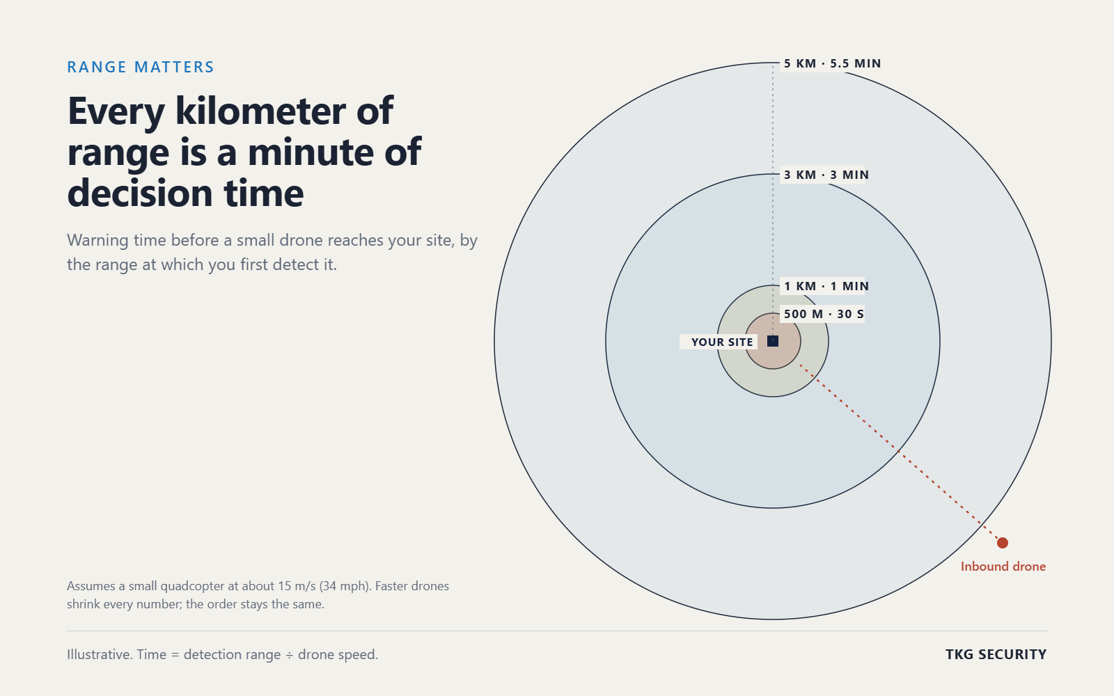
The single biggest difference between aware and prepared is detection range. Every extra kilometer of range is extra time, and time is what turns an alarm into a decision.
A typical small quadcopter cruises at about 15 meters per second, roughly 34 mph. At that speed, here is how much warning each detection range gives you, and what you can do with it:
| Detection range | Warning before it reaches you | What that time allows |
|---|---|---|
| 500 m | ~30 seconds | Alert and shelter. Little else. |
| 1 km | ~1 minute | Cue a camera, confirm the target, alert security. |
| 3 km | ~3 minutes | Confirm, lock down the right areas, start locating the pilot. |
| 5 km | ~5.5 minutes | All of the above, plus calling police and an authorized response before arrival. |
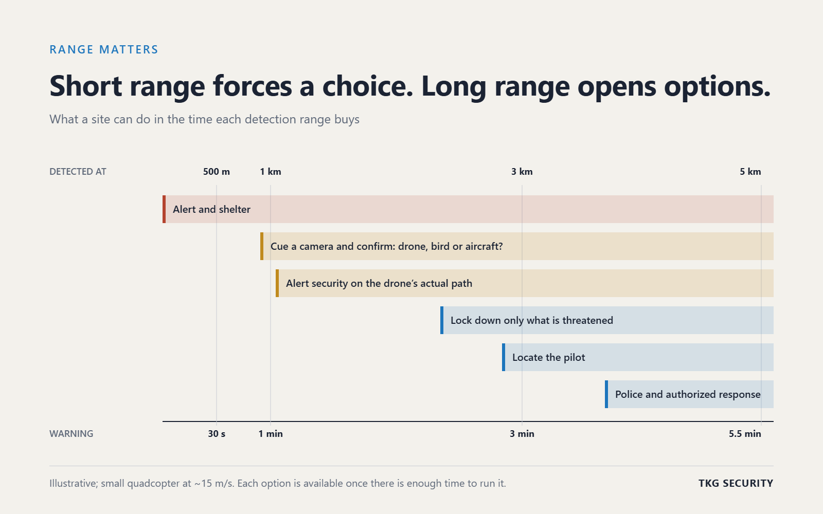
Short range forces a binary choice: ignore it or shut everything down. Long range opens a menu. You can confirm before you disrupt operations, protect only what is on the drone's path, and hand police a pilot location while the drone is still in the air.
Range also cuts false alarms. With time to slew a camera and classify the object, a bird or a crewed aircraft's lights never becomes a runway closure.
Want your own numbers? The Range and Warning Time Planner works them out from your detection range, drone speed and response times.
Not all detection is equal
When you evaluate vendors, range is only the first question. A system that sees a drone at 500 meters, loses it, then finds it again is not giving you minutes. It is giving you a series of alarms.
We would rule out three kinds of systems for any site that is serious about drones:
- Short-range radar. If first detection of a small drone is a few hundred meters, you are back in the unaware group with a sensor attached. You get seconds, not options.
- Intermittent tracking. A track that drops in and out cannot be followed, handed to a camera or given to police. Ask for continuous track custody from first detection to the fence.
- Camera-only (EO/IR) detection. Cameras are excellent for confirming what a radar has found. On their own they search a narrow field of view, struggle at night and in weather, and miss what they are not pointed at.
What to ask for instead: long-range detection of small drones, consistent tracks with position, altitude and heading every update, and cameras used to confirm, not to search. Ask every vendor for live or recorded track data from a real site, not a brochure range. The playbook includes a vendor evaluation checklist you can use.
Where do you stand?
Five questions place most sites in one of the three groups:
- How many drones flew near your site last month, and how do you know?
- When a drone is reported, can you confirm it on camera within a minute?
- How far out do you first detect a small drone?
- Is there a written playbook, and has anyone run it?
- Could you hand police a pilot location and a track history today?
If the honest answer to the first question is "we don't know," you are in group one. If you can answer it but not the rest, you are in group two. Most sites we meet are in one of those two.
Moving to group three rarely starts with hardware. It starts with a site model: what you need to protect, where drones come from, and how much range each approach needs. That is the work we do at TKG Security with CoreDesign, before anything is installed, and then with CoreCommand, which fuses every sensor into one confirmed track and drives the response.
The drones are already flying. The only choice left is how early you see them, and what you do with the time.
Download the free toolkit
Drone Incident Response Playbook (Word) · Range and Warning Time Planner (Excel)
Want help applying it to your site? Talk to a TKG engineer.
Warning times are illustrative and assume a small quadcopter at about 15 m/s. The playbook is a sample template, not legal advice.